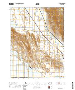
2020 Map of Lost River
USGS Topo · Published 2020About this map
Klamath Hills and Stukel Mtn dominate this agricultural and high-desert landscape situated along the border of Oregon and California. The map captures a complex irrigation network essential to this region, featuring the winding Lost River and man-made channels like the G Canal. These water systems serve the Spring Lake Valley and surrounding basins, where historical land use is marked by family-run operations such as the Long Ranch Airport. Cultural markers provide deep ties for genealogists, including the Mount Laki Cem near Mount Laki and the Independent Order of Odd Fellows Cem further south. The transition from high ridges like Manning Ridge to the low-lying White Lake reflects the unique topography of the Klamath Basin, while infrastructure like the Stukel Bridge illustrates the local transport patterns used to navigate this watery terrain.
Find a feature on this map
42 named features on this map. Tap any name to fly to it.
Don’t see what you’re looking for? This feature index may not catch every label — zoom into the map to look around manually.
Map Details
Editions of this 2020 Lost River Map
This is the sole edition of this map. No revisions or reprints were ever made.
Other maps of this area

1886 · Modoc Lava Bed
USGS Topo · 1:250,000

1889 · Klamath
USGS Topo · 1:250,000

1892 · Modoc Lava-Bed
USGS Topo · 1:250,000

1894 · Klamath
USGS Topo · 1:250,000

1950 · Mt. Dome
USGS Topo · 1:62,500

1950 · Dorris
USGS Topo · 1:62,500

1954 · Alturas
USGS Topo · 1:250,000

1955 · Klamath Falls
USGS Topo · 1:250,000

1957 · Merrill
USGS Topo · 1:62,500

1957 · Klamath Falls
USGS Topo · 1:62,500