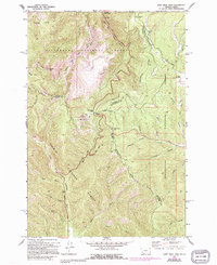
1966 Map of Lost Trail Pass
USGS Topo · Published 1994About this map
The Continental Divide winds through this high-altitude junction of the Northern Rockies, serving as the dramatic boundary between Bitterroot National Forest, Salmon National Forest, and Beaverhead National Forest. This mapping, updated through the early 1990s, documents a landscape shaped by both natural drainage and human passage at the state line between Montana and Idaho. Key mountain crossings like Lost Trail Pass, Chief Joseph Pass, and Gibbons Pass are the focal points of the terrain, connected by the winding path of Highway 93. Signs of mid-century infrastructure and forest management are evident at the Hogans Guard Sta and the Lookout Tower atop Saddle Mtn. The map also captures local recreational and industrial features, including a Sports Area, a Roadside Park, and a Gravel Pit, alongside the headwaters of the North Fork Salmon River and Camp Creek.
Find a feature on this map
41 named features on this map. Tap any name to fly to it.
Don’t see what you’re looking for? This feature index may not catch every label — zoom into the map to look around manually.
Map Details
Editions of this 1966 Lost Trail Pass Map
3 editions found
Other maps of this area

1955 · Dillon
USGS Topo · 1:250,000

1956 · Elk City
USGS Topo · 1:250,000

1957 · Dillon
USGS Topo · 1:250,000

1958 · Dillon
USGS Topo · 1:250,000

1960 · Elk City
USGS Topo · 1:250,000

1960 · Piquett Mountain
USGS Topo · 1:62,500

1962 · Dillon
USGS Topo · 1:250,000

1965 · Dillon
USGS Topo · 1:250,000

1965 · Medicine Hot Springs
USGS Topo · 1:24,000

1966 · Lost Trail Pass
USGS Topo · 1:24,000