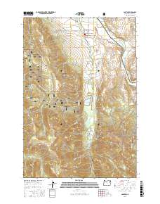
2017 Map of Lostine
USGS Topo · Published 2017About this map
The settlement of Lostine sits at the confluence of the Lostine River and Wallowa River, serving as a gateway to the high-elevation landscapes of the Wallowa National Forest. This 2017 survey reveals a sophisticated water management system defined by numerous gravity-fed channels, including the Westside-Ditch, Cross Country Ditch, and Poley-Allen Ditch, which redirect river flow across the valley floor to support the region's agricultural interests. Moving south from the valley, the terrain rises sharply into the timbered slopes of Huckleberry Mtn and Sheep Ridge. The presence of Lostine Reservoir and various family-named features like McCoy Flats and Womack Basin illustrate how the geography is defined by both industrial water engineering and localized homestead history. From the depths of Allen Canyon to the heights of Wades Point, the map documents a place where mountain hydrology and valley ranching are inextricably linked.
Find a feature on this map
43 named features on this map. Tap any name to fly to it.
Don’t see what you’re looking for? This feature index may not catch every label — zoom into the map to look around manually.
Map Details
Editions of this 2017 Lostine Map
This is the sole edition of this map. No revisions or reprints were ever made.
Other maps of this area

1906 · Telocaset
USGS Topo · 1:125,000

1955 · Grangeville
USGS Topo · 1:250,000

1957 · Enterprise
USGS Topo · 1:62,500

1957 · Sled Springs
USGS Topo · 1:62,500

1959 · Grangeville
USGS Topo · 1:250,000

1964 · Wallowa
USGS Topo · 1:24,000

1965 · Fox Point
USGS Topo · 1:24,000
1966 · Jim White Ridge
USGS Topo · 1:24,000

1982 · Wallowa
USGS Topo · 1:100,000

1986 · Enterprise
USGS Topo · 1:100,000