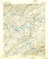
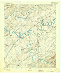
1895 Map of Loudon
USGS Topo · Published 1939About this map
The Tennessee River and Little Tennessee River wind through this East Tennessee landscape, defining the commerce and movement of the late 19th century. Extensive ferry networks, including Tipton Ferry and Huff Fy., provide essential crossings in an era before widespread bridging, while the Chattanooga and Bristol Div. railroad anchors major valley settlements. This reconnaissance survey captures the rural layout of Loudon, Monroe, and Blount counties, highlighting educational landmarks like Hiwassee College and Ewing Academy that served as local cultural hubs. The map illustrates a transitional economy where agrarian life at Burns Mill met the growing industrial presence at Lenoir. To the southeast, the terrain rises toward the Cherokee National Forest and the heights of Chilhowee Mtn., marking the shift from the broad river valleys to the foothills of the Smokies.
Find a feature on this map
122 named features on this map. Tap any name to fly to it.
Don’t see what you’re looking for? This feature index may not catch every label — zoom into the map to look around manually.
Map Details
Editions of this 1895 Loudon Map
6 editions found

Other maps of this area

1886 · Cleveland
USGS Topo · 1:125,000

1886 · Knoxville
USGS Topo · 1:125,000

1887 · Kingston
USGS Topo · 1:125,000

1891 · Kingston
USGS Topo · 1:125,000

1892 · Cleveland
USGS Topo · 1:125,000

1892 · Knoxville
USGS Topo · 1:125,000

1893 · Murphy
USGS Topo · 1:125,000

1893 · Briceville
USGS Topo · 1:125,000

1893 · Kingston
USGS Topo · 1:125,000

1894 · Knoxville
USGS Topo · 1:125,000