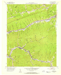
1954 Map of Louellen
USGS Topo · Published 1956About this map
Louellen and Highsplint sit at the center of this 1954 topographical study, revealing the heavy industrial footprint of the eastern Kentucky coalfields. Following the winding course of the Clover Fork, the L & N railroad connects a string of coal camps and company towns including Black Bottom, Closplint, and Clover-Darby. The landscape is dominated by the massive ridges of Pine Mountain and Black Mountain, which hem in these narrow hollows.
Find a feature on this map
110 named features on this map. Tap any name to fly to it.
Don’t see what you’re looking for? This feature index may not catch every label — zoom into the map to look around manually.
Map Details
Editions of this 1954 Louellen Map
4 editions found
Other maps of this area

1887 · Jonesville
USGS Topo · 1:125,000

1890 · Whitesburg
USGS Topo · 1:125,000

1891 · Hazard
USGS Topo · 1:125,000

1891 · Jonesville
USGS Topo · 1:125,000

1892 · Whitesburg
USGS Topo · 1:125,000

1894 · Estillville
USGS Topo · 1:125,000

1913 · Oven Fork
USGS Topo · 1:48,000

1915 · Whitesburg
USGS Topo · 1:62,500

1916 · Cornettsville
USGS Topo · 1:62,500

1916 · Nolansburg
USGS Topo · 1:48,000