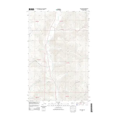
2014 Map of Louie Creek
USGS Topo · Published 2014About this map
The Sanpoil River valley carves through the heart of the Colville Indian Reservation in this 2014 topographic study. This segment of Ferry County is defined by a dense network of drainage systems feeding the main river channel, including Louie Cr, Cache Cr, and Bridge Cr. The landscape is etched with the Bureau of Indian Affairs road system, such as BIA 83 Rd and BIA 94 Rd, which navigate the steep elevations of the Colville National Forest region. State Route Wa-21 serves as the primary north-south artery, following the river's path. Other significant tributaries like Lime Cr and Fortymile Cr illustrate the complex hydrology of this high-elevation plateau, where water and topography dictate the limited human infrastructure and road placement.
Find a feature on this map
30 named features on this map. Tap any name to fly to it.
Don’t see what you’re looking for? This feature index may not catch every label — zoom into the map to look around manually.
Map Details
Editions of this 2014 Louie Creek Map
This is the sole edition of this map. No revisions or reprints were ever made.
Other maps of this area

1950 · Nespelem
USGS Topo · 1:62,500

1952 · Keller
USGS Topo · 1:62,500

1953 · Seventeenmile Mtn.
USGS Topo · 1:62,500

1953 · Bald Knob
USGS Topo · 1:62,500

1954 · Okanogan
USGS Topo · 1:250,000

1958 · Okanogan
USGS Topo · 1:250,000

1984 · Nespelem
USGS Topo · 1:100,000

1986 · Central Peak
USGS Topo · 1:24,000
1989 · Keller
USGS Topo · 1:24,000
1989 · Nespelem NE
USGS Topo · 1:24,000