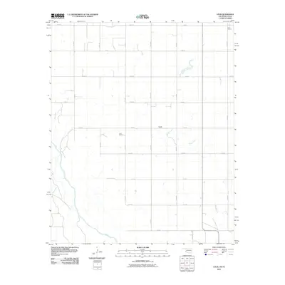
2010 Map of Louis
USGS Topo · Published 2010About this map
The Red River forms a sweeping southwestern boundary in this 2010 depiction of the Oklahoma-Texas borderlands. The landscape is primarily defined by a rigid section-line road grid, including e1650 RD and n1770 RD, which segments the agricultural terrain of Harmon County. The small community of Louis serves as a central point of reference, situated near the headwaters of a branch of Sandy Creek. Genealogists and local historians will find significant markers of the area's early settlement in the presence of Louis Cemetery and Liberty Cemetery, the latter located in the northeastern corner of the quadrangle. The hydrology of the region is further characterized by the meandering path of Tepee Creek as it approaches its confluence with the river, illustrating the drainage patterns that have shaped land use in this border territory.
Find a feature on this map
21 named features on this map. Tap any name to fly to it.
Don’t see what you’re looking for? This feature index may not catch every label — zoom into the map to look around manually.
Map Details
Editions of this 2010 Louis Map
This is the sole edition of this map. No revisions or reprints were ever made.
Other maps of this area

1955 · Lawton
USGS Topo · 1:250,000

1960 · Goodlett
USGS Topo · 1:62,500

1960 · Quanah
USGS Topo · 1:62,500

1961 · Hollis
USGS Topo · 1:62,500

1971 · Mc Queen
USGS Topo · 1:24,000

1971 · Duke SW
USGS Topo · 1:24,000

1975 · Hollis NE
USGS Topo · 1:24,000

1975 · Hollis SE
USGS Topo · 1:24,000

1975 · Quanah NW
USGS Topo · 1:24,000
1975 · Hollis NW
USGS Topo · 1:24,000