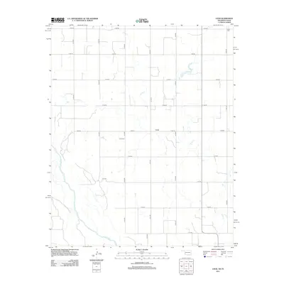
2012 Map of Louis
USGS Topo · Published 2012About this map
Sandy Creek meanders across this rural landscape in Harmon County, defining the drainage patterns north of the Red River. The settlement of Louis serves as the central point of a rigid grid of section-line roads, including E 1690 Road and N 1770 Road. This 2012 survey illustrates the enduring agricultural layout of the Oklahoma-Texas borderlands, where family and community history is anchored by sites like Louis Cemetery and Liberty Cemetery near the northeastern corner. The western edge is marked by the shifting path of the Red River, which acts as a natural boundary between states. This map is particularly useful for researchers tracing the modern infrastructure and surviving landmarks of this sparsely populated frontier region.
Find a feature on this map
21 named features on this map. Tap any name to fly to it.
Don’t see what you’re looking for? This feature index may not catch every label — zoom into the map to look around manually.
Map Details
Editions of this 2012 Louis Map
This is the sole edition of this map. No revisions or reprints were ever made.
Other maps of this area

1955 · Lawton
USGS Topo · 1:250,000

1960 · Goodlett
USGS Topo · 1:62,500

1960 · Quanah
USGS Topo · 1:62,500

1961 · Hollis
USGS Topo · 1:62,500

1971 · Mc Queen
USGS Topo · 1:24,000

1971 · Duke SW
USGS Topo · 1:24,000

1975 · Hollis NE
USGS Topo · 1:24,000

1975 · Hollis SE
USGS Topo · 1:24,000

1975 · Quanah NW
USGS Topo · 1:24,000
1975 · Hollis NW
USGS Topo · 1:24,000