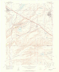
1957 Map of Louisville
USGS Topo · Published 1958About this map
Davidson Mesa and the industrial activity of the northern Colorado coalfields define this mid-century landscape. The area around Marshall and Superior is heavily marked by subsurface extraction, featuring numerous sites such as the Cracker Jack Mine, Eldorado Mine, and the Industrial Mine. These coal operations are interspersed with a complex water management system of ditches and reservoirs, including Marshall Lake and the Great Western Reservoir. The modern era is represented by the diagonal sweep of the Denver Boulder Turnpike, which cuts across the traditional rail corridors of the Colorado and Southern Railroad. To the south, the open expanse of Rocky Flats transitions into the foothills near Shanahan Hill, while the growing community of Louisville anchors the northeastern portion of the survey near the Louisville Reservoir.
Find a feature on this map
61 named features on this map. Tap any name to fly to it.
Don’t see what you’re looking for? This feature index may not catch every label — zoom into the map to look around manually.
Map Details
Editions of this 1957 Louisville Map
2 editions found
Other maps of this area

1899 · West Denver
USGS Topo · 1:125,000

1902 · Boulder
USGS Topo · 1:62,500

1904 · Niwot
USGS Topo · 1:62,500

1904 · Boulder
USGS Topo · 1:62,500

1906 · Blackhawk
USGS Topo · 1:62,500

1939 · Golden
USGS Topo · 1:24,000

1940 · Lafayette
USGS Topo · 1:31,680

1941 · Arvada
USGS Topo · 1:31,680

1942 · Eldorado Springs
USGS Topo · 1:24,000

1942 · Golden
USGS Topo · 1:31,680