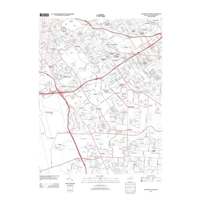
2013 Map of Louisville East
USGS Topo · Published 2013About this map
Cave Hill National Cemetery and its adjacent Cave Hill Cemetery stand as central landmarks in this detailed record of Louisville's eastern suburban expansion. The landscape is a dense network of post-war residential developments, including the Strathmoor communities, Seneca Gardens, and Audubon Park. Infrastructure defines the modern character of the area, anchored by Bowman Field Airport and the sprawling complex of Louisville International Airport-Standiford Field to the southwest.
Find a feature on this map
68 named features on this map. Tap any name to fly to it.
Don’t see what you’re looking for? This feature index may not catch every label — zoom into the map to look around manually.
Map Details
Editions of this 2013 Louisville East Map
This is the sole edition of this map. No revisions or reprints were ever made.
Other maps of this area

1905 · Prospect
USGS Topo · 1:62,500

1907 · Louisville
USGS Topo · 1:62,500

1909 · Kosmosdale
USGS Topo · 1:48,000

1912 · Prospect
USGS Topo · 1:62,500

1912 · Kosmosdale
USGS Topo · 1:62,500

1937 · Jeffersonville
USGS Topo · 1:24,000

1939 · New Albany
USGS Topo · 1:24,000

1946 · Jeffersonville
USGS Topo · 1:24,000

1946 · New Albany
USGS Topo · 1:24,000
1950 · New Albany
USGS Topo · 1:24,000