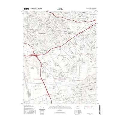
2016 Map of Louisville East
USGS Topo · Published 2016About this map
The dense suburban and urban expansion of Louisville is meticulously documented here, showing a landscape defined by its major institutions and thoroughfares. The northeastern portion is dominated by the sprawling grounds of Cave Hill Cem and Eastern Cem, while higher education is represented by campuses such as Bellarmine Univ and The Southern Baptist Theological Seminary. The map illustrates the complex drainage systems of the region, including the Middle Fork Beargrass Creek and the South Fork Beargrass Creek, which wind through neighborhoods like the Highlands and Seneca Gardens. Significant aviation hubs are anchored at Bowman Field and the Louisville International Airport-Standiford Field, reflecting the city's role as a transportation nexus. The transition from established neighborhoods like German Town to newer developments such as Okolona and Heritage Creek highlights the diverse residential character of Jefferson County.
Find a feature on this map
72 named features on this map. Tap any name to fly to it.
Don’t see what you’re looking for? This feature index may not catch every label — zoom into the map to look around manually.
Map Details
Editions of this 2016 Louisville East Map
This is the sole edition of this map. No revisions or reprints were ever made.
Other maps of this area

1905 · Prospect
USGS Topo · 1:62,500

1907 · Louisville
USGS Topo · 1:62,500

1909 · Kosmosdale
USGS Topo · 1:48,000

1912 · Prospect
USGS Topo · 1:62,500

1912 · Kosmosdale
USGS Topo · 1:62,500

1937 · Jeffersonville
USGS Topo · 1:24,000

1939 · New Albany
USGS Topo · 1:24,000

1946 · Jeffersonville
USGS Topo · 1:24,000

1946 · New Albany
USGS Topo · 1:24,000
1950 · New Albany
USGS Topo · 1:24,000