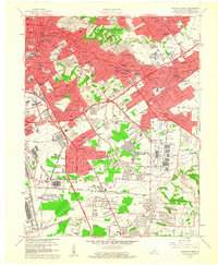
1960 Map of Louisville East
USGS Topo · Published 1961About this map
Louisville is shown at a peak of post-war suburbanization, with its eastern neighborhoods and independent cities like St Matthews and Buechel expanding rapidly into former farmland. The landscape is dominated by large-scale institutional and transportation infrastructure, from the dual airports of Bowman Field and Standiford Field to the massive industrial complex at Appliance Park. Residential development follows the curves of Cherokee Park and Seneca Park, while the new Henry Watterson Expressway begins to reshape the city's connectivity.
Find a feature on this map
101 named features on this map. Tap any name to fly to it.
Don’t see what you’re looking for? This feature index may not catch every label — zoom into the map to look around manually.
Map Details
Editions of this 1960 Louisville East Map
This is the sole edition of this map. No revisions or reprints were ever made.
Other maps of this area

1905 · Prospect
USGS Topo · 1:62,500

1907 · Louisville
USGS Topo · 1:62,500

1909 · Kosmosdale
USGS Topo · 1:48,000

1912 · Prospect
USGS Topo · 1:62,500

1912 · Kosmosdale
USGS Topo · 1:62,500

1937 · Jeffersonville
USGS Topo · 1:24,000

1939 · New Albany
USGS Topo · 1:24,000

1946 · Jeffersonville
USGS Topo · 1:24,000

1946 · New Albany
USGS Topo · 1:24,000
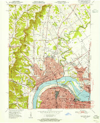
1950 · New Albany
USGS Topo · 1:24,000