
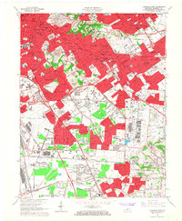
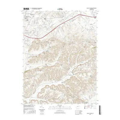
1965 Map of Louisville East
USGS Topo · Published 1972About this map
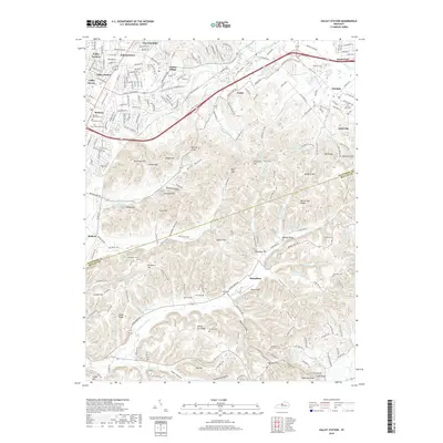
The suburban expansion of Louisville east and south is documented here during a period of significant postwar growth. The landscape is defined by the winding paths of the Middle Fork Beargrass Creek and South Fork Beargrass Creek, which contrast with the emerging grid of residential developments like Audubon Park, Lynnview, and Hikes Point. Major aviation hubs anchor the region, with the expansive grounds of Standiford Field featuring the Lee Terminal, while Bowman Field serves the area to the northeast. Cultural and educational institutions are well-established, including Bellarmine College and Ursuline College. Large green spaces and memorial grounds occupy significant acreage, notably the sprawling Cave Hill Cemetery and Calvary Cemetery. The infrastructure reflects a shift toward automobile-centric transit, highlighted by the Henry Watterson Expressway and Preston Highway, which intersect the older rail corridors of the Louisville And Nashville and Southern railroads.
Find a feature on this map
105 named features on this map. Tap any name to fly to it.
Don’t see what you’re looking for? This feature index may not catch every label — zoom into the map to look around manually.
Map Details
Editions of this 1965 Louisville East Map
2 editions found
Historical Maps of Louisville Through Time
48 maps found

1909 Kosmosdale
Jefferson County, KY

1912 Kosmosdale
Jefferson County, KY

1950 Kosmosdale
Jefferson County, KY

1951 Fisherville
Jefferson County, KY

1951 Louisville East
Jefferson County, KY

1951 Valley Station
Jefferson County, KY

1953 Madison East
Jefferson County, KY

1955 Louisville East
Jefferson County, KY

1955 Louisville West
Jefferson County, KY

1955 Valley Station
Jefferson County, KY

1960 Fisherville
Jefferson County, KY

1960 Louisville East
Jefferson County, KY

1960 Louisville West
Jefferson County, KY

1960 Valley Station
Jefferson County, KY
1965 Louisville East
Jefferson County, KY

1965 Louisville West
Jefferson County, KY

1981 Kosmosdale
Jefferson County, KY

1982 Fisherville
Jefferson County, KY

1982 Louisville East
Jefferson County, KY

1982 Valley Station
Jefferson County, KY

1983 Louisville West
Jefferson County, KY

1993 Valley Station
Jefferson County, KY

1998 Louisville West
Jefferson County, KY

2010 Fisherville
Jefferson County, KY

2010 Louisville East
Jefferson County, KY

2010 Louisville West
Jefferson County, KY

2010 Valley Station
Jefferson County, KY

2011 Kosmosdale
Jefferson County, KY

2013 Fisherville
Jefferson County, KY

2013 Kosmosdale
Jefferson County, KY

2013 Louisville East
Jefferson County, KY
2013 Louisville West
Jefferson County, KY

2013 Valley Station
Jefferson County, KY
2016 Fisherville
Jefferson County, KY

2016 Kosmosdale
Jefferson County, KY

2016 Louisville East
Jefferson County, KY
2016 Louisville West
Jefferson County, KY
2016 Valley Station
Jefferson County, KY
2019 Fisherville
Jefferson County, KY
2019 Kosmosdale
Jefferson County, KY
2019 Louisville East
Jefferson County, KY

2019 Louisville West
Jefferson County, KY
2019 Valley Station
Jefferson County, KY

2022 Fisherville
Jefferson County, KY

2022 Kosmosdale
Jefferson County, KY

2022 Louisville East
Jefferson County, KY

2022 Louisville West
Jefferson County, KY

2022 Valley Station
Jefferson County, KY