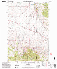
2001 Map of Louisville
USGS Topo · Published 2004About this map
Louisville and Clasoil sit along the primary transport corridor in this high-plains landscape, where the valley floor meets the rising elevations of the Spokane Hills. The map documents a transition from the engineered water management of the Helena Valley Canal in the north to the protected timberlands of the Helena National Forest in the south. Local industry and education are represented by the Economy Mine and the Spokane Creek School, indicating a settled rural community. The complex topography is defined by numerous drainage systems including Mitchell Gulch, Corral Creek, and Deep Gulch, which carve through the terrain near prominent landmarks like Little Butte. This 2001 revision illustrates the convergence of three counties—Lewis and Clark, Jefferson, and Broadwater—within a landscape shaped by both natural resource extraction and modern infrastructure like the prominent Pipeline.
Find a feature on this map
22 named features on this map. Tap any name to fly to it.
Don’t see what you’re looking for? This feature index may not catch every label — zoom into the map to look around manually.
Map Details
Editions of this 2001 Louisville Map
This is the sole edition of this map. No revisions or reprints were ever made.
Other maps of this area

1886 · Fort Logan
USGS Topo · 1:250,000

1899 · Helena
USGS Topo · 1:62,500

1948 · White Sulphur Springs
USGS Topo · 1:250,000

1950 · Canyon Ferry
USGS Topo · 1:62,500

1950 · Townsend
USGS Topo · 1:62,500

1950 · East Helena
USGS Topo · 1:62,500

1950 · Clancy
USGS Topo · 1:62,500

1958 · White Sulphur Springs
USGS Topo · 1:250,000

1961 · White Sulphur Springs
USGS Topo · 1:250,000

1965 · White Sulphur Springs
USGS Topo · 1:250,000