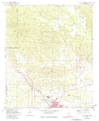
1972 Map of Louisville North
USGS Topo · Published 1982About this map
The Tombigbee National Forest dominates the northern landscape of this Winston County survey, where the Noxubee River and Little Noxubee River carve through a heavily wooded terrain. This region preserves a mix of rural infrastructure and forest management, evidenced by the Lookout Tower and scattered family landmarks like Tanksley Cem and Noxubee Hill Cem. To the south, the city of Louisville serves as a hub of activity, with its residential streets like Pontotoc St and Columbus Ave clearly delineated near the Louisville-Winston County Airport. The industrial and transit character of the era is defined by the Illinois Central Gulf railroad line, which passes through McMillan and Greenboro, connecting local Kilns and timber resources to wider markets. Small country congregations such as West Union Ch and Union Chapel mark the persistent rural communities nestled between the forest boundary and the expanding town center.
Find a feature on this map
42 named features on this map. Tap any name to fly to it.
Don’t see what you’re looking for? This feature index may not catch every label — zoom into the map to look around manually.
Map Details
Editions of this 1972 Louisville North Map
2 editions found
Other maps of this area

1953 · West Point
USGS Topo · 1:250,000

1958 · West Point
USGS Topo · 1:250,000

1963 · West Point
USGS Topo · 1:250,000

1965 · Bradley
USGS Topo · 1:24,000

1972 · Louisville North
USGS Topo · 1:24,000

1972 · Highpoint
USGS Topo · 1:24,000
1972 · Louisville South
USGS Topo · 1:24,000
1972 · Louisville SW
USGS Topo · 1:24,000

1972 · Sturgis
USGS Topo · 1:24,000
1972 · Ackerman
USGS Topo · 1:24,000