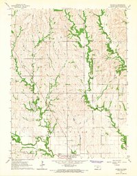
1964 Map of Louisville
USGS Topo · Published 1965About this map
The settlement of Louisville anchors this mid-century survey of Pottawatomie County, positioned near the confluence of Rock Creek and Elm Slough. A significant historical landmark is the Old Indian Treaty Boundary which cuts diagonally across the central landscape, marking an older era of land division. The terrain is defined by a dense network of drainages including Adams Creek, Boxelder Creek, and Brush Creek, many of which are flanked by wooded bottomlands. For local historians, the map identifies several burial sites like the Old County Farm Cem and Pleasant Hill Cem. The inclusion of fine red dashed lines indicates fence and field lines as they appeared during 1959 aerial photography, providing a detailed view of agricultural partitioning before the mid-1960s field check. Economic activity is represented by a Gravel Pit and the presence of the Vermillion Cr on the eastern edge.
Find a feature on this map
21 named features on this map. Tap any name to fly to it.
Don’t see what you’re looking for? This feature index may not catch every label — zoom into the map to look around manually.
Map Details
Editions of this 1964 Louisville Map
2 editions found
Other maps of this area

1889 · Wamego
USGS Topo · 1:125,000

1894 · Wamego
USGS Topo · 1:125,000

1953 · Wamego
USGS Topo · 1:24,000

1953 · St George
USGS Topo · 1:24,000

1953 · Belvue
USGS Topo · 1:24,000

1955 · Manhattan
USGS Topo · 1:250,000

1956 · Manhattan
USGS Topo · 1:250,000

1957 · Manhattan
USGS Topo · 1:250,000
1964 · Westmoreland
USGS Topo · 1:24,000
1964 · Laclede
USGS Topo · 1:24,000