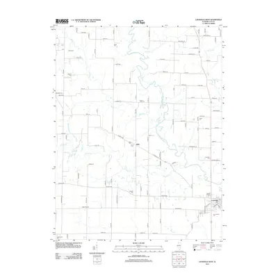
2012 Map of Louisville West
USGS Topo · Published 2012About this map
The Little Wabash River winds through the heart of this landscape, its serpentine path defining the drainage for numerous tributaries like Dismal Cr, Crooked Cr, and Panther Cr. The settlement of Louisville anchors the southeastern corner of the map, serving as a hub near the Old Louisville Cem and Orchard Hill Cem. To the west, the rural community of Little Prairie and the tiny hamlet of Riffle represent the enduring agricultural character of the county. For those researching local lineages, the map is remarkably dense with family-named burial grounds, including the Tolliver Cem, Newton Chapel Cem, and Speaks Cem. Evidence of the region's mineral industry appears in the southwest at the Oskaloosa Oil Field, where specialized land use interrupts the traditional township grid. This 2012 survey provides a detailed look at the rural road network and the way these small communities evolved around the winding river bottomlands.
Find a feature on this map
101 named features on this map. Tap any name to fly to it.
Don’t see what you’re looking for? This feature index may not catch every label — zoom into the map to look around manually.
Map Details
Editions of this 2012 Louisville West Map
This is the sole edition of this map. No revisions or reprints were ever made.
Other maps of this area

1948 · Flora
USGS Topo · 1:62,500

1949 · Flora
USGS Topo · 1:62,500

1952 · Xenia
USGS Topo · 1:62,500

1953 · Sailor Springs
USGS Topo · 1:62,500

1956 · Edgewood
USGS Topo · 1:62,500

1958 · Belleville
USGS Topo · 1:250,000

1962 · Belleville
USGS Topo · 1:250,000
1968 · Xenia
USGS Topo · 1:24,000
1968 · Xenia NE
USGS Topo · 1:24,000
1970 · Flora
USGS Topo · 1:24,000