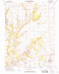
1968 Map of Xenia
USGS Topo · Published 1970About this map
Xenia sits at the intersection of energy extraction and rail transport in the late 1960s, anchored by the Baltimore and Ohio railroad and the adjacent Xenia Oil Field. The landscape is a mosaic of agriculture and industrial infrastructure, with oil wells scattered across the eastern sections of Oskaloosa and Songer townships. To the west, the creation of Forbes Lake and the establishment of Stephen A. Forbes State Park introduced new recreational dimensions to the region, complete with picnic areas and a fish hatchery.
Find a feature on this map
47 named features on this map. Tap any name to fly to it.
Don’t see what you’re looking for? This feature index may not catch every label — zoom into the map to look around manually.
Map Details
Editions of this 1968 Xenia Map
2 editions found
Other maps of this area

1934 · Salem
USGS Topo · 1:62,500

1938 · Salem
USGS Topo · 1:62,500

1945 · Kinmundy
USGS Topo · 1:62,500

1947 · Kinmundy
USGS Topo · 1:62,500

1952 · Xenia
USGS Topo · 1:62,500

1956 · Edgewood
USGS Topo · 1:62,500

1958 · Belleville
USGS Topo · 1:250,000

1962 · Belleville
USGS Topo · 1:250,000

1965 · Iuka
USGS Topo · 1:24,000
1965 · Omega
USGS Topo · 1:24,000