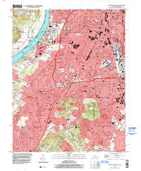
1998 Map of Louisville West
USGS Topo · Published 2000About this map
Louisville and its western suburbs are detailed in this late 20th-century survey, showcasing the dense residential and industrial expansion between the Ohio River and the high ground of Iroquois Park. The urban fabric is dominated by established neighborhoods like Shively, South Parkland, and Beechmont, with the legendary Churchill Downs racetrack serving as a central landmark. The industrial and logistical character of the era is evident in the heavy presence of the Illinois Central Gulf RR and the sprawling U S Naval Ordnance Plant to the south.
Find a feature on this map
60 named features on this map. Tap any name to fly to it.
Don’t see what you’re looking for? This feature index may not catch every label — zoom into the map to look around manually.
Map Details
Editions of this 1998 Louisville West Map
This is the sole edition of this map. No revisions or reprints were ever made.
Other maps of this area

1905 · Prospect
USGS Topo · 1:62,500

1907 · Louisville
USGS Topo · 1:62,500

1909 · Kosmosdale
USGS Topo · 1:48,000

1912 · Prospect
USGS Topo · 1:62,500

1912 · Kosmosdale
USGS Topo · 1:62,500

1937 · Jeffersonville
USGS Topo · 1:24,000

1939 · New Albany
USGS Topo · 1:24,000

1939 · Georgetown
USGS Topo · 1:24,000

1946 · Jeffersonville
USGS Topo · 1:24,000

1946 · New Albany
USGS Topo · 1:24,000