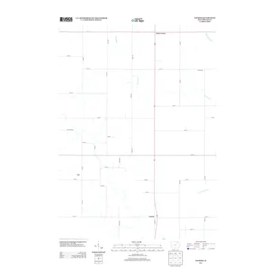
2013 Map of Lourdes
USGS Topo · Published 2013About this map
Lourdes and Davis Corners anchor this rural Howard County landscape, which is defined by a systematic grid of agricultural roads and the meandering path of the Turkey River. The river's reach is further detailed by its named forks, including the W Br Turkey River in the northeast and the S Br Turkey River in the southeast. Named agricultural sites such as Caffrey Farm and Ludwig Farm provide specific points of interest for genealogists tracing local land ownership. This survey illustrates the persistent rural character of the region in the early 21st century, where large-scale farming remains the primary economic driver. A network of arterial routes like Crane Creek Rd and Lourdes Rd connects these isolated farmsteads to the crossroads settlements that have served the community for generations.
Find a feature on this map
30 named features on this map. Tap any name to fly to it.
Don’t see what you’re looking for? This feature index may not catch every label — zoom into the map to look around manually.
Map Details
Editions of this 2013 Lourdes Map
This is the sole edition of this map. No revisions or reprints were ever made.
Other maps of this area

1954 · Mason City
USGS Topo · 1:250,000

1957 · Mason City
USGS Topo · 1:250,000

1958 · Mason City
USGS Topo · 1:250,000

1972 · Elma
USGS Topo · 1:24,000

1972 · Jerico
USGS Topo · 1:24,000

1981 · Lourdes
USGS Topo · 1:24,000

1981 · Cresco NW
USGS Topo · 1:24,000

1981 · Lime Springs
USGS Topo · 1:24,000
1981 · Saude
USGS Topo · 1:24,000
1981 · Cresco SW
USGS Topo · 1:24,000