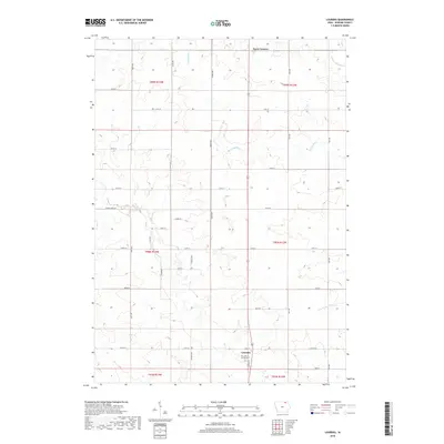
2018 Map of Lourdes
USGS Topo · Published 2018About this map
Lourdes and Davis Corners anchor this rural Howard County landscape, which remains defined by its agricultural grid and the winding paths of the Turkey River. The settlement at Lourdes is centered on Lourdes Rd and 175th St, where Our Lady of Lourdes Cem serves as a significant landmark for local genealogy and history. The terrain is deeply etched by the river's various branches, including the W Br Turkey River in the northeast and the S Br Turkey River in the southeast. This survey illustrates the persistent township and range structure of Iowa's farmland, with north-south corridors like Kent Ave and Lilac Ave bisecting the drainage basins. The map captures the interface between these rectilinear farm boundaries and the organic, meandering waterways that dictated early land use and local geography.
Find a feature on this map
34 named features on this map. Tap any name to fly to it.
Don’t see what you’re looking for? This feature index may not catch every label — zoom into the map to look around manually.
Map Details
Editions of this 2018 Lourdes Map
This is the sole edition of this map. No revisions or reprints were ever made.
Other maps of this area

1954 · Mason City
USGS Topo · 1:250,000

1957 · Mason City
USGS Topo · 1:250,000

1958 · Mason City
USGS Topo · 1:250,000

1972 · Elma
USGS Topo · 1:24,000

1972 · Jerico
USGS Topo · 1:24,000

1981 · Lourdes
USGS Topo · 1:24,000

1981 · Cresco NW
USGS Topo · 1:24,000

1981 · Lime Springs
USGS Topo · 1:24,000
1981 · Saude
USGS Topo · 1:24,000
1981 · Cresco SW
USGS Topo · 1:24,000