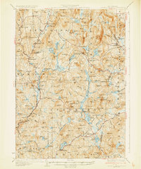
1930 Map of Lovewell Mountain
USGS Topo · Published 1930About this map
Highland Lake and the surrounding highlands of the Monadnock region define this landscape, where the Ashuelot River drainage meets the rugged granite terrain of southwestern New Hampshire. In this era, small rural centers like Washington and Marlow serve as focal points for a network of winding roads and scattered homesteads. The map highlights the early 20th-century transition toward seasonal recreation with labels for the State Forest Camp and Windsor Mtn Camp, alongside established lakeside settlements like Munsonville.
Find a feature on this map
186 named features on this map. Tap any name to fly to it.
Don’t see what you’re looking for? This feature index may not catch every label — zoom into the map to look around manually.
Map Details
Editions of this 1930 Lovewell Mountain Map
4 editions found

Other maps of this area

1898 · Monadnock
USGS Topo · 1:62,500

1898 · Keene
USGS Topo · 1:62,500

1900 · Peterboro
USGS Topo · 1:62,500

1902 · Sunapee
USGS Topo · 1:62,500

1905 · Sunapee
USGS Topo · 1:62,500

1907 · Sunapee
USGS Topo · 1:62,500

1926 · Hillsboro
USGS Topo · 1:62,500

1926 · Claremont
USGS Topo · 1:62,500

1927 · Bellows Falls
USGS Topo · 1:48,000

1928 · Mount Kearsarge
USGS Topo · 1:62,500