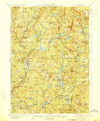
1930 Map of Lovewell Mountain
USGS Topo · Published 1930About this map
Marlow and Stoddard anchor this upland New Hampshire landscape, where the headwaters of the Ashuelot River and numerous ponds define the local industry and movement. The presence of Loverens Mills, Mill Village, and Gee Mill suggests a terrain utilized for water-powered production, while the Dartmouth College Road and State Highway provide the primary transit corridors through the hills. This 1930 edition utilizes early aerial photography from the Air Corps, U.S. Army, to refine the details of the numerous water bodies, including Island Pond and Granite Lake.
Find a feature on this map
163 named features on this map. Tap any name to fly to it.
Don’t see what you’re looking for? This feature index may not catch every label — zoom into the map to look around manually.
Map Details
Editions of this 1930 Lovewell Mountain Map
4 editions found

Other maps of this area

1898 · Monadnock
USGS Topo · 1:62,500

1898 · Keene
USGS Topo · 1:62,500

1900 · Peterboro
USGS Topo · 1:62,500

1902 · Sunapee
USGS Topo · 1:62,500

1905 · Sunapee
USGS Topo · 1:62,500

1907 · Sunapee
USGS Topo · 1:62,500

1926 · Hillsboro
USGS Topo · 1:62,500

1926 · Claremont
USGS Topo · 1:62,500

1927 · Bellows Falls
USGS Topo · 1:48,000

1928 · Mount Kearsarge
USGS Topo · 1:62,500