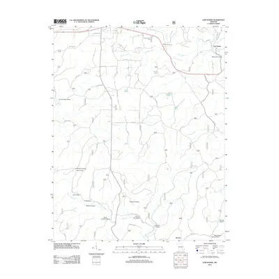
2012 Map of Low Wassie
USGS Topo · Published 2012About this map
Low Wassie and Brawley anchor this portion of the Ozark landscape, where the terrain is defined by an intricate network of hollows and seasonal watercourses. The local geography is heavily influenced by the drainage patterns of Pike Creek and the southern Hurricane Creek, which carve out named features like Saltpetre Hollow and Possum Trot Hollow. Transportation history is visible in the presence of Old Tram Rd and Tram Lookout, suggesting the region's historical connection to timber or industrial rail paths. In the northern reaches, the Twinpine Picnic Area and Mount Zion Cemetery serve as landmarks of community and recreation. The map also captures numerous localized water bodies such as Nichols Lake, Tram Pond, and Grassy Pond, reflecting the diverse hydrologic character of Shannon County's southern hills.
Find a feature on this map
49 named features on this map. Tap any name to fly to it.
Don’t see what you’re looking for? This feature index may not catch every label — zoom into the map to look around manually.
Map Details
Editions of this 2012 Low Wassie Map
This is the sole edition of this map. No revisions or reprints were ever made.
Other maps of this area

1915 · Eminence
USGS Topo · 1:62,500

1917 · Eminence
USGS Topo · 1:62,500

1928 · Cardareva
USGS Topo · 1:62,500

1931 · Bandyville
USGS Topo · 1:48,000

1944 · Van Buren
USGS Topo · 1:62,500

1944 · Birch Tree
USGS Topo · 1:62,500

1946 · Van Buren
USGS Topo · 1:62,500

1948 · Birch Tree
USGS Topo · 1:62,500

1949 · Rolla
USGS Topo · 1:250,000

1949 · Cardareva
USGS Topo · 1:62,500