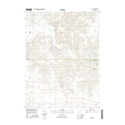
2015 Map of Lowell
USGS Topo · Published 2015About this map
The settlement of Lowell sits at a prominent bend in the Skunk River, serving as a central point in this rural landscape where Henry, Lee, and Des Moines counties converge. The terrain is defined by a dense network of tributaries including Big Creek, Mud Cr, and Prairie Cr that carve through the agricultural uplands. This 2015 survey is particularly valuable for genealogists, as it documents an extensive number of small burial sites and family plots scattered across the countryside, such as the Abbe Cem, Bethany Cem, and the uniquely named Emerson Plot. To the east, the waters of Geode Lake and the smaller Lake Wilderness offer a contrast to the surrounding farmsteads. The map also captures the local road network, from established routes like Salem Rd to the more secluded Shady Oak Ln, illustrating the enduring spatial organization of these Iowa townships.
Find a feature on this map
56 named features on this map. Tap any name to fly to it.
Don’t see what you’re looking for? This feature index may not catch every label — zoom into the map to look around manually.
Map Details
Editions of this 2015 Lowell Map
This is the sole edition of this map. No revisions or reprints were ever made.
Other maps of this area

1936 · Fort Madison
USGS Topo · 1:62,500

1958 · Burlington
USGS Topo · 1:250,000

1961 · Burlington
USGS Topo · 1:250,000

1963 · Burlington
USGS Topo · 1:250,000

1964 · West Point
USGS Topo · 1:24,000
1964 · Fort Madison
USGS Topo · 1:24,000

1968 · Donnellson
USGS Topo · 1:24,000

1981 · Mount Pleasant
USGS Topo · 1:24,000
1981 · Danville
USGS Topo · 1:24,000
1981 · Lowell
USGS Topo · 1:24,000