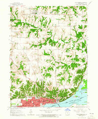
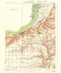
1964 Map of Fort Madison
USGS Topo · Published 1965About this map
Fort Madison dominates this mid-1960s survey, showing its dense urban grid pressed against the Mississippi River. The city’s geography is defined by the Fort Madison Corporate Boundary and the prominent State Penitentiary grounds on the eastern waterfront. To the north, the landscape transitions into the agricultural plateaus of Denmark and Washington townships, carved by the deep ravines of Lost Creek and Mud Creek. Transportation is a central theme, with the Chicago Burlington and Quincy railroad hugging the shoreline and the Fort Madison Municipal Airport and Riddles Airstrip serving the rural uplands. Genealogists will find a wealth of named burial sites, from Claypoole Cem in the hills to Elmwood Cem and Oakland Cem within the town. The river itself reveals a complex of named features like Lead Island and Dutchman Island, separated by the Lead Island Chute.
Find a feature on this map
62 named features on this map. Tap any name to fly to it.
Don’t see what you’re looking for? This feature index may not catch every label — zoom into the map to look around manually.
Map Details
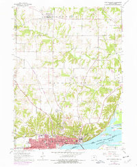
Editions of this 1964 Fort Madison Map
2 editions found
Other maps of this area
1932 · Lomax
USGS Topo · 1:62,500

1934 · Burlington
USGS Topo · 1:48,000
1936 · Fort Madison
USGS Topo · 1:62,500
1937 · Lomax
USGS Topo · 1:62,500

1940 · Burlington
USGS Topo · 1:62,500

1958 · Burlington
USGS Topo · 1:250,000

1961 · Burlington
USGS Topo · 1:250,000

1963 · Burlington
USGS Topo · 1:250,000
1964 · Nauvoo
USGS Topo · 1:24,000
1964 · West Point
USGS Topo · 1:24,000