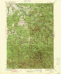
1942 Map of Lowell
USGS Topo · Published 1942About this map
Willamette River tributaries define the landscape of this region, where the Southern Pacific and Oregon and Southeastern railroads follow the winding river valleys. During the 1930s, this area of Lane and Douglas counties was characterized by a network of rural schools and isolated homesteads, such as the Smithson Homestead and Palmer Ranch. The settlement at Lowell serves as a central point between the rugged uplands of the Willamette National Forest and the Umpqua National Forest.
Find a feature on this map
179 named features on this map. Tap any name to fly to it.
Don’t see what you’re looking for? This feature index may not catch every label — zoom into the map to look around manually.
Map Details
Editions of this 1942 Lowell Map
3 editions found

Other maps of this area

1897 · Roseburg
USGS Topo · 1:125,000

1900 · Roseburg
USGS Topo · 1:125,000

1910 · Eugene
USGS Topo · 1:62,500

1917 · Diamond Lake
USGS Topo · 1:125,000

1921 · Cottage Grove
USGS Topo · 1:62,500

1925 · Waldo Lake
USGS Topo · 1:125,000

1934 · Mc Kenzie Bridge
USGS Topo · 1:96,000

1935 · Lowell
USGS Topo · 1:96,000

1940 · Mc Kenzie Bridge
USGS Topo · 1:125,000

1940 · Eugene
USGS Topo · 1:62,500