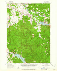
1955 Map of Lowell
USGS Topo · Published 1961About this map
The Middle Fork Willamette River and Coast Fork Willamette River shape this mid-1950s landscape, illustrating the major hydraulic transformations of the mid-20th century. The newly formed Dexter Reservoir, anchored by the Lookout Point Dam, has altered the valley floor near Lowell, while the Dorena Reservoir dominates the southern edge of the survey area near the Row River. This era shows the coexistence of traditional farming settlements like Pleasant Hill and Cloverdale with the critical infrastructure of the Southern Pacific Railroad and the Oregon Pacific and Eastern Railway. Local history is preserved in landmarks such as the Cloverdale Cem and Cloverdale Sch, while the presence of a Quarry and various spillways reflects the region's industrial and engineering activity.
Find a feature on this map
59 named features on this map. Tap any name to fly to it.
Don’t see what you’re looking for? This feature index may not catch every label — zoom into the map to look around manually.
Map Details
Editions of this 1955 Lowell Map
3 editions found

Other maps of this area

1910 · Eugene
USGS Topo · 1:62,500

1921 · Cottage Grove
USGS Topo · 1:62,500

1935 · Lowell
USGS Topo · 1:96,000

1940 · Eugene
USGS Topo · 1:62,500

1942 · Lowell
USGS Topo · 1:125,000

1946 · Eugene
USGS Topo · 1:62,500

1949 · Eugene
USGS Topo · 1:62,500

1950 · Marcola
USGS Topo · 1:62,500

1951 · Leaburg
USGS Topo · 1:62,500

1952 · Marcola
USGS Topo · 1:62,500