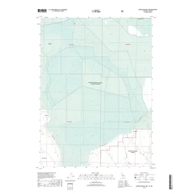
2018 Map of Lower Klamath Lake
USGS Topo · Published 2018About this map
The Lower Klamath National Wildlife Refuge dominates this section of Siskiyou County, protecting an intricate wetland ecosystem defined by Lower Klamath Lake and the Lower Klamath Lake Sump. This landscape is heavily managed for water conservation and habitat, as seen in the extensive network of canals and dikes that partition the marshlands. Notable high ground and shore features like Fairchild Island and Coyote Point emerge from the basin, while the southeastern corner shifts toward the timberlands of the Modoc National Forest. Transportation is confined to perimeter routes like Lower Klamath Rd and Dorris Brownell Rd, which serve the agricultural and conservation areas surrounding Sardine Flat and the elevated Big Tableland. This survey captures the vital intersection of regional water management and the rugged volcanic terrain of the California-Oregon borderlands.
Find a feature on this map
20 named features on this map. Tap any name to fly to it.
Don’t see what you’re looking for? This feature index may not catch every label — zoom into the map to look around manually.
Map Details
Editions of this 2018 Lower Klamath Lake Map
This is the sole edition of this map. No revisions or reprints were ever made.
Other maps of this area

1886 · Modoc Lava Bed
USGS Topo · 1:250,000

1889 · Klamath
USGS Topo · 1:250,000

1892 · Modoc Lava-Bed
USGS Topo · 1:250,000

1894 · Klamath
USGS Topo · 1:250,000

1950 · Mt. Dome
USGS Topo · 1:62,500

1950 · Dorris
USGS Topo · 1:62,500

1954 · Alturas
USGS Topo · 1:250,000

1955 · Klamath Falls
USGS Topo · 1:250,000

1957 · Merrill
USGS Topo · 1:62,500

1957 · Klamath Falls
USGS Topo · 1:62,500