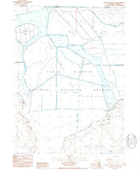
1985 Map of Lower Klamath Lake
USGS Topo · Published 1985About this map
The Lower Klamath National Wildlife Refuge dominates this mid-1980s survey, revealing a landscape defined by water management and conservation along the California-Oregon border. The area is a complex network of levees, canals, and dikes that regulate the waters of Lower Klamath Lake and White Lake. This man-made hydrological system transformed the region from natural marshland into a patchwork of inundation zones and managed basins, visible here as the refuge borders the timbered slopes of the Modoc National Forest. Distinctive landmarks such as Coyote Point and Fairchild Island rise above the wetlands, while Chalk Bank Landing marks a point of access along the eastern refuge boundary. To the south, the terrain shifts abruptly as the flat marshlands meet the rising elevations of the Big Tableland, reflecting the transition from the lake basin to the volcanic plateaus of Siskiyou County.
Find a feature on this map
14 named features on this map. Tap any name to fly to it.
Don’t see what you’re looking for? This feature index may not catch every label — zoom into the map to look around manually.
Map Details
Editions of this 1985 Lower Klamath Lake Map
This is the sole edition of this map. No revisions or reprints were ever made.
Other maps of this area

1886 · Modoc Lava Bed
USGS Topo · 1:250,000

1889 · Klamath
USGS Topo · 1:250,000

1892 · Modoc Lava-Bed
USGS Topo · 1:250,000

1894 · Klamath
USGS Topo · 1:250,000

1950 · Mt. Dome
USGS Topo · 1:62,500

1950 · Dorris
USGS Topo · 1:62,500

1954 · Alturas
USGS Topo · 1:250,000

1955 · Klamath Falls
USGS Topo · 1:250,000

1957 · Merrill
USGS Topo · 1:62,500

1957 · Klamath Falls
USGS Topo · 1:62,500