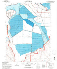
1993 Map of Lower Klamath Lake
USGS Topo · Published 1997About this map
Lower Klamath National Wildlife Refuge dominates this landscape, revealing a complex hydraulic environment defined by reclaimed lands and managed wetlands. The map illustrates a vast network of infrastructure including Road on Levee segments and numerous levee systems that partition Lower Klamath Lake and White Lake. This engineered landscape is characterized by areas noted as Subject to Inundation, showing the careful balance of water control in the basin.
Find a feature on this map
21 named features on this map. Tap any name to fly to it.
Don’t see what you’re looking for? This feature index may not catch every label — zoom into the map to look around manually.
Map Details
Editions of this 1993 Lower Klamath Lake Map
This is the sole edition of this map. No revisions or reprints were ever made.
Other maps of this area

1886 · Modoc Lava Bed
USGS Topo · 1:250,000

1889 · Klamath
USGS Topo · 1:250,000

1892 · Modoc Lava-Bed
USGS Topo · 1:250,000

1894 · Klamath
USGS Topo · 1:250,000

1950 · Mt. Dome
USGS Topo · 1:62,500

1950 · Dorris
USGS Topo · 1:62,500

1954 · Alturas
USGS Topo · 1:250,000

1955 · Klamath Falls
USGS Topo · 1:250,000

1957 · Merrill
USGS Topo · 1:62,500

1957 · Klamath Falls
USGS Topo · 1:62,500