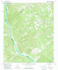
1964 Map of Lowndesville
USGS Topo · Published 1989About this map
Lowndesville stands as the primary settlement in this 1960s survey of the borderlands between South Carolina and Georgia. The landscape is defined by the convergence of major waterways, where the Savannah River and Rocky River meet near McCalla Island. The Atlantic Coast Line railroad cuts through the terrain, connecting the rural communities and providing a vital transport corridor for the region's agricultural economy.
Find a feature on this map
33 named features on this map. Tap any name to fly to it.
Don’t see what you’re looking for? This feature index may not catch every label — zoom into the map to look around manually.
Map Details
Editions of this 1964 Lowndesville Map
3 editions found
Other maps of this area

1893 · Elberton
USGS Topo · 1:125,000

1954 · Greenville
USGS Topo · 1:250,000

1958 · Greenville
USGS Topo · 1:250,000

1958 · Elberton
USGS Topo · 1:62,500

1959 · Hartwell Dam
USGS Topo · 1:24,000

1964 · Iva
USGS Topo · 1:24,000

1964 · Antreville
USGS Topo · 1:24,000

1964 · Lowndesville
USGS Topo · 1:24,000
1964 · Calhoun Falls
USGS Topo · 1:24,000
1964 · Latimer
USGS Topo · 1:24,000