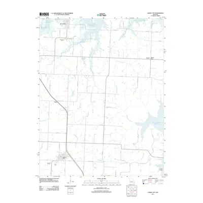
2011 Map of Lowry City
USGS Topo · Published 2011About this map
Lowry City and Brownington serve as the primary population centers in this St. Clair County landscape, defined by the expansive reaches of the Harry S Truman Reservoir. The reservoir’s presence dominates the northern and eastern portions of the map, flooding the historic drainage basins of Big Muddy Creek and Little Muddy Creek. This 2011 survey captures the modern road network, including Co Hwy NE 1100 and Co Hwy NE 800, which connect smaller communities like Chloe and Mount Zion. Genealogists and local historians will find significant value in the detailed plotting of area burial grounds, such as Maplewood Cemetery, Brownington Cemetery, Mount Zion Cemetery, and Lowry City Cemetery. The terrain is further characterized by the meandering courses of Big Otter Creek and Gallinipper Creek, alongside landmarks like Turkey Hollow and Ackley Lake, illustrating the intersection of natural waterways and managed water resources in western Missouri.
Find a feature on this map
54 named features on this map. Tap any name to fly to it.
Don’t see what you’re looking for? This feature index may not catch every label — zoom into the map to look around manually.
Map Details
Editions of this 2011 Lowry City Map
This is the sole edition of this map. No revisions or reprints were ever made.
Other maps of this area

1887 · Clinton
USGS Topo · 1:125,000

1894 · Clinton
USGS Topo · 1:125,000

1938 · Monegaw Springs
USGS Topo · 1:24,000

1939 · Osceola
USGS Topo · 1:24,000

1940 · Osceola
USGS Topo · 1:24,000
1940 · Monegaw Springs
USGS Topo · 1:24,000

1940 · Iconium
USGS Topo · 1:24,000

1941 · Valhalla
USGS Topo · 1:24,000

1941 · Lowry City
USGS Topo · 1:24,000
1944 · Iconium
USGS Topo · 1:24,000