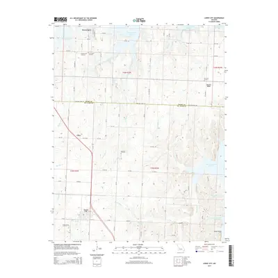
2014 Map of Lowry City
USGS Topo · Published 2014About this map
Lowry City and the surrounding borderlands of St. Clair and Henry counties are defined by the expansive reaches of the Harry S Truman Reservoir. This modern survey illustrates how the Osage River valley's landscape has been reshaped, with fingers of the reservoir now filling old creek beds like Big Muddy Cr and Hay Cr. Despite these changes, the fundamental grid of the countryside remains visible, connecting established settlements like Brownington and Mount Zion via a network of rural roads such as Lakeland School Rd.
Find a feature on this map
63 named features on this map. Tap any name to fly to it.
Don’t see what you’re looking for? This feature index may not catch every label — zoom into the map to look around manually.
Map Details
Editions of this 2014 Lowry City Map
This is the sole edition of this map. No revisions or reprints were ever made.
Other maps of this area

1887 · Clinton
USGS Topo · 1:125,000

1894 · Clinton
USGS Topo · 1:125,000

1938 · Monegaw Springs
USGS Topo · 1:24,000

1939 · Osceola
USGS Topo · 1:24,000

1940 · Osceola
USGS Topo · 1:24,000
1940 · Monegaw Springs
USGS Topo · 1:24,000

1940 · Iconium
USGS Topo · 1:24,000

1941 · Valhalla
USGS Topo · 1:24,000

1941 · Lowry City
USGS Topo · 1:24,000
1944 · Iconium
USGS Topo · 1:24,000