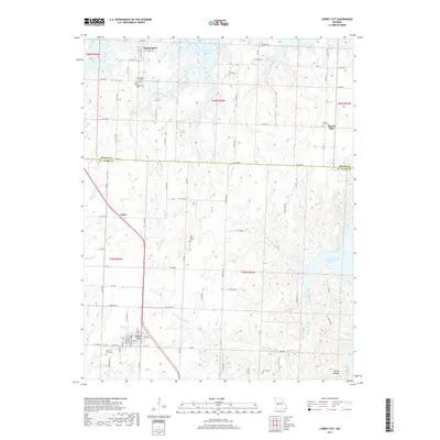
2017 Map of Lowry City
USGS Topo · Published 2017About this map
Lowry City sits in the southern portion of this landscape, serving as a hub for the surrounding rural communities of Brownington and Mount Zion. This region of St. Clair and Henry Counties is defined by the expansive fingers of the Harry S Truman Reservoir, which fill the valleys of several tributaries including Big Muddy Cr and Little Otter Cr. The settlement pattern reflects a deeply rooted community infrastructure, with numerous family and town burial grounds such as Lowry City Cem, Brownington Cem, and Park Grove Cem distributed across the high ground between the drainage basins. The varied terrain shifts from the level creek bottoms to localized features like Turkey Hollow and the waters of Ackley Lake. A complex network of county roads and state highways connects these points, following the ridges above the marshy wetlands and shoreline of the reservoir.
Find a feature on this map
85 named features on this map. Tap any name to fly to it.
Don’t see what you’re looking for? This feature index may not catch every label — zoom into the map to look around manually.
Map Details
Editions of this 2017 Lowry City Map
This is the sole edition of this map. No revisions or reprints were ever made.
Other maps of this area

1887 · Clinton
USGS Topo · 1:125,000

1894 · Clinton
USGS Topo · 1:125,000

1938 · Monegaw Springs
USGS Topo · 1:24,000

1939 · Osceola
USGS Topo · 1:24,000

1940 · Osceola
USGS Topo · 1:24,000
1940 · Monegaw Springs
USGS Topo · 1:24,000

1940 · Iconium
USGS Topo · 1:24,000

1941 · Valhalla
USGS Topo · 1:24,000

1941 · Lowry City
USGS Topo · 1:24,000
1944 · Iconium
USGS Topo · 1:24,000