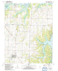
1991 Map of Lowry City
USGS Topo · Published 1992About this map
Lowry City and Brownington anchor this western Missouri landscape, surveyed during a period of significant hydrological transition. The northern and eastern reaches are defined by the rising waters of the Harry S Truman Reservoir, which has submerged portions of the South Grand R and Osage R valleys. This inundation reshaped the geography near the State Wildlife Area, creating a complex shoreline where the Otter Creek and Big Creek drainages meet the reservoir.
Find a feature on this map
32 named features on this map. Tap any name to fly to it.
Don’t see what you’re looking for? This feature index may not catch every label — zoom into the map to look around manually.
Map Details
Editions of this 1991 Lowry City Map
This is the sole edition of this map. No revisions or reprints were ever made.
Other maps of this area

1887 · Clinton
USGS Topo · 1:125,000

1894 · Clinton
USGS Topo · 1:125,000

1938 · Monegaw Springs
USGS Topo · 1:24,000

1939 · Osceola
USGS Topo · 1:24,000

1940 · Osceola
USGS Topo · 1:24,000
1940 · Monegaw Springs
USGS Topo · 1:24,000

1940 · Iconium
USGS Topo · 1:24,000

1941 · Valhalla
USGS Topo · 1:24,000

1941 · Lowry City
USGS Topo · 1:24,000
1944 · Iconium
USGS Topo · 1:24,000