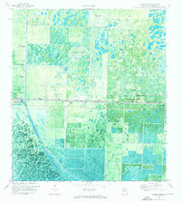
1971 Map of Loxahatchee
USGS Topo · Published 1976About this map
The Loxahatchee National Wildlife Refuge and Conservation Area No 1 dominate the southwestern corner of this survey, illustrating the managed intersection of Florida’s natural wetlands and industrial water control. The landscape is defined by an extensive network of waterways, including the West Palm Beach Canal, L-40 Canal, L-8 Canal, and L-7 Canal, which dictate the drainage and transit patterns of the region.
Find a feature on this map
16 named features on this map. Tap any name to fly to it.
Don’t see what you’re looking for? This feature index may not catch every label — zoom into the map to look around manually.
Map Details
Editions of this 1971 Loxahatchee Map
This is the sole edition of this map. No revisions or reprints were ever made.
Other maps of this area

1945 · Delta
USGS Topo · 1:24,000

1945 · Greenacres City
USGS Topo · 1:24,000

1946 · Palm Beach Farms
USGS Topo · 1:24,000

1949 · Palm Beach Farms
USGS Topo · 1:24,000

1950 · Greenacres City
USGS Topo · 1:24,000

1950 · Delta
USGS Topo · 1:24,000

1956 · West Palm Beach
USGS Topo · 1:250,000

1957 · West Palm Beach
USGS Topo · 1:250,000

1958 · West Palm Beach
USGS Topo · 1:250,000

1970 · West Palm Beach 2 SW
USGS Topo · 1:24,000