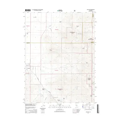
2015 Map of Loyalton
USGS Topo · Published 2015About this map
Loyalton sits at the southern edge of the Sierra Valley, serving as a primary settlement node where the valley floor meets the rising timberlands of the Tahoe National Forest. The local geography is defined by a series of steep canyons, including Correco Canyon and Badenaugh Canyon, which channel water toward the valley. Significant peaks like Mt Ina Coolbrith and Elephants Head overlook the town and the smaller community of Sierra Brooks. The map documents a rural network of roads such as Smithneck Rd and Beckwith St that connect the town's residential core, marked by the Post Office and Cemetery, to the outlying range lands. The convergence of Toiyabe National Forest and Tahoe lands indicates a landscape managed for both timber and watershed protection, with Smithneck Creek providing a vital riparian corridor through the dry canyon floors.
Find a feature on this map
39 named features on this map. Tap any name to fly to it.
Don’t see what you’re looking for? This feature index may not catch every label — zoom into the map to look around manually.
Map Details
Editions of this 2015 Loyalton Map
This is the sole edition of this map. No revisions or reprints were ever made.
Other maps of this area

1890 · Sierraville
USGS Topo · 1:125,000

1892 · Sierraville
USGS Topo · 1:125,000

1894 · Sierraville
USGS Topo · 1:125,000

1950 · Chilcoot
USGS Topo · 1:62,500

1950 · Portola
USGS Topo · 1:62,500

1955 · Loyalton
USGS Topo · 1:62,500

1955 · Sierraville
USGS Topo · 1:62,500

1958 · Chico
USGS Topo · 1:250,000

1960 · Chico
USGS Topo · 1:250,000
1972 · Reconnaissance Peak
USGS Topo · 1:24,000