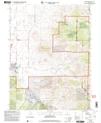
2000 Map of Loyalton
USGS Topo · Published 2003About this map
Loyalton serves as the primary hub in this corner of the eastern Sierra, where the flat floor of the Sierra Valley meets the rising terrain of the Bald Mountain Range. The map illustrates a landscape transitioning from agriculture and industry to public land management, with the Alvin A Powers Memorial Grove and extensive reaches of the Tahoe National Forest and Toiyabe National Forest dominating the eastern and southern quadrants. Evidence of local infrastructure and genealogy can be traced through the Cem south of town, several irrigation features like Flowing Wells, and a Gaging Station on Smithneck Creek. Rural life is centered along historical routes such as Dotta Lane and Staverville Road, while peaks like Mount Ina Coolbrith and the distinctive Elephants Head define the high country skyline.
Find a feature on this map
31 named features on this map. Tap any name to fly to it.
Don’t see what you’re looking for? This feature index may not catch every label — zoom into the map to look around manually.
Map Details
Editions of this 2000 Loyalton Map
This is the sole edition of this map. No revisions or reprints were ever made.
Other maps of this area

1890 · Sierraville
USGS Topo · 1:125,000

1892 · Sierraville
USGS Topo · 1:125,000

1894 · Sierraville
USGS Topo · 1:125,000

1950 · Chilcoot
USGS Topo · 1:62,500

1950 · Portola
USGS Topo · 1:62,500

1955 · Loyalton
USGS Topo · 1:62,500

1955 · Sierraville
USGS Topo · 1:62,500

1958 · Chico
USGS Topo · 1:250,000

1960 · Chico
USGS Topo · 1:250,000
1972 · Reconnaissance Peak
USGS Topo · 1:24,000