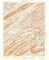
1933 Map of Loysville
USGS Topo · Published 1933About this map
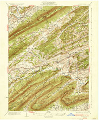
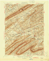
Tuscarora Mountain and Blue Mountain define the corrugated topography of Perry County in the early 1930s, framing a landscape of narrow agricultural valleys and ridge-top woodlands. The area is densely dotted with small rural institutions, including dozens of neighborhood schoolhouses like Wisdom Sch, Spring Grove Sch, and Manassas Sch. Central hubs such as Loysville and Landisburg anchor the local economy, while smaller crossroads like Ickesburg and Cisna Run serve outlying farms.
Find a feature on this map
126 named features on this map. Tap any name to fly to it.
Don’t see what you’re looking for? This feature index may not catch every label — zoom into the map to look around manually.
Map Details
Editions of this 1933 Loysville Map
3 editions found
Other maps of this area

1904 · Carlisle
USGS Topo · 1:62,500

1907 · New Bloomfield
USGS Topo · 1:62,500

1907 · Millerstown
USGS Topo · 1:62,500

1919 · Newville
USGS Topo · 1:62,500

1919 · Mattawana
USGS Topo · 1:62,500

1923 · Shippensburg
USGS Topo · 1:62,500

1924 · Lewistown
USGS Topo · 1:62,500

1925 · Mifflintown
USGS Topo · 1:48,000

1927 · Lewisburg
USGS Topo · 1:62,500

1930 · Loysville
USGS Topo · 1:62,500
Featured Places
- Saville Township, PA
- Centre, Southwest Madison Township
- Spruce Hill Township, PA
- Landisburg, PA
- Milford Township, PA