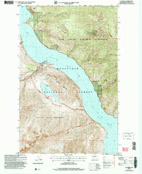
2004 Map of Lucerne
USGS Topo · Published 2008About this map
Lake Chelan dominates this landscape, serving as the primary transportation corridor for the settlement at Lucerne. In the early 21st century, this area remains defined by its isolation and the deep glacial waters that cut through the surrounding peaks. The map reveals the vital role of the Ferry system in connecting these remote points, including the Moore Point (Site) and the docks at Refrigerator Harbor.
Find a feature on this map
28 named features on this map. Tap any name to fly to it.
Don’t see what you’re looking for? This feature index may not catch every label — zoom into the map to look around manually.
Map Details
Editions of this 2004 Lucerne Map
This is the sole edition of this map. No revisions or reprints were ever made.
Other maps of this area

1899 · Methow
USGS Topo · 1:125,000

1901 · Methow
USGS Topo · 1:125,000

1902 · Stehekin
USGS Topo · 1:125,000

1904 · Stehekin
USGS Topo · 1:125,000

1944 · Lucerne
USGS Topo · 1:62,500

1949 · Lucerne
USGS Topo · 1:62,500

1955 · Concrete
USGS Topo · 1:250,000

1958 · Concrete
USGS Topo · 1:250,000

1962 · Concrete
USGS Topo · 1:250,000
1968 · Big Goat Mtn
USGS Topo · 1:24,000