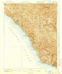
1921 Map of Lucia
USGS Topo · Published 1941About this map
Tassajara Hot Springs and Slates Hot Springs serve as early focal points for settlement along the dramatic coastline of the Santa Lucia Range. Based on a 1917 survey by R.B. Marshall and Geo. R. Davis, this map illustrates a period when access to the Big Sur coast was primarily defined by treacherous overland trails and maritime landings. Coastal activity is centered around remote points like Anderson Landing and Rockland Landing, which facilitated the transport of goods before the completion of modern highways. Inland, the landscape is dotted with isolated homesteads and family names such as Sobranes, Dolan, and Twitchells. The presence of the Redwood School near Vicente Creek suggests a small but established community of ranching families and loggers working the steep canyons. Deep drainages like Big Sur River and Anderson Canyon carve through the ridge system, connecting high-elevation grazing areas like Horse Pasture to the Pacific Ocean.
Find a feature on this map
61 named features on this map. Tap any name to fly to it.
Don’t see what you’re looking for? This feature index may not catch every label — zoom into the map to look around manually.
Map Details
Editions of this 1921 Lucia Map
4 editions found
Other maps of this area

1915 · Soledad
USGS Topo · 1:62,500

1918 · Point Sur
USGS Topo · 1:62,500

1919 · Junipero Serra
USGS Topo · 1:62,500

1920 · Jamesburg
USGS Topo · 1:48,000

1921 · Cape San Martin
USGS Topo · 1:62,500

1921 · Jamesburg
USGS Topo · 1:62,500

1921 · Lucia
USGS Topo · 1:62,500

1925 · Point Sur
USGS Topo · 1:62,500

1939 · Jamesburg
USGS Topo · 1:62,500

1940 · Jamesburg
USGS Topo · 1:62,500