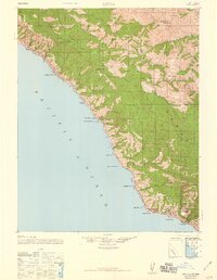
1947 Map of Lucia
USGS Topo · Published 1959About this map
The Santa Lucia Range dominates this stretch of the California coast, where steep ridges drop directly into the Pacific Ocean. This 1947 edition, based on earlier surveys and 1939 aerial photography, reveals a landscape defined by isolated homesteads and small coastal settlements before the modernization of the shoreline. The Lucia P. O. serves as a central landmark for the area, surrounded by family-named locations such as Harlan, Danis, and Boronda. Further inland, the map traces the deep canyons of the South Fork Big Sur River and the high elevations of Anderson Peak. Of particular interest to local historians are the early educational sites like Seaview School and Redwood School, as well as established recreational and natural sites such as Tassajara Hot Springs and Indian Valley. Small maritime access points, including Anderson Landing and Rockland Landing, highlight the historical reliance on the sea for transport along this challenging terrain.
Find a feature on this map
61 named features on this map. Tap any name to fly to it.
Don’t see what you’re looking for? This feature index may not catch every label — zoom into the map to look around manually.
Map Details
Editions of this 1947 Lucia Map
3 editions found

Other maps of this area

1915 · Soledad
USGS Topo · 1:62,500

1918 · Point Sur
USGS Topo · 1:62,500

1919 · Junipero Serra
USGS Topo · 1:62,500

1920 · Jamesburg
USGS Topo · 1:48,000

1921 · Cape San Martin
USGS Topo · 1:62,500

1921 · Jamesburg
USGS Topo · 1:62,500

1921 · Lucia
USGS Topo · 1:62,500

1925 · Point Sur
USGS Topo · 1:62,500

1939 · Jamesburg
USGS Topo · 1:62,500

1940 · Jamesburg
USGS Topo · 1:62,500