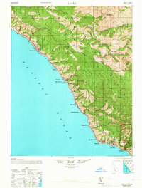
1947 Map of Lucia
USGS Topo · Published 1967About this map
The Santa Lucia Range rises sharply from the Pacific Ocean in this mid-century topographic record of the Big Sur coast. Family names mark the coastline and canyons, with sites like Andersen, Dolan, and Waters appearing alongside the small coastal settlement of Lucia. The terrain is characterized by steep ridges like Logwood Ridge and deep drainage basins for the North Fork Sur River and South Fork Sur River. Inland, the Hunter Liggett Military Reservation occupies the southeastern corner of the sheet, contrasting with the remote recreational and school sites such as Seaview School and the Tassajara Hot Springs in the northeast. The presence of coastal landings like Andersen Landing and Rockland Landing indicates the historical maritime access points necessary for this isolated stretch of Monterey County before modern highway development fully transformed the region.
Find a feature on this map
64 named features on this map. Tap any name to fly to it.
Don’t see what you’re looking for? This feature index may not catch every label — zoom into the map to look around manually.
Map Details
Editions of this 1947 Lucia Map
3 editions found

Other maps of this area

1915 · Soledad
USGS Topo · 1:62,500

1918 · Point Sur
USGS Topo · 1:62,500

1919 · Junipero Serra
USGS Topo · 1:62,500

1920 · Jamesburg
USGS Topo · 1:48,000

1921 · Cape San Martin
USGS Topo · 1:62,500

1921 · Jamesburg
USGS Topo · 1:62,500

1921 · Lucia
USGS Topo · 1:62,500

1925 · Point Sur
USGS Topo · 1:62,500

1939 · Jamesburg
USGS Topo · 1:62,500

1940 · Jamesburg
USGS Topo · 1:62,500