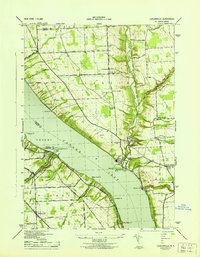
1943 Map of Ludlowville
USGS Topo · Published 1943About this map
Taughannock Falls State Park dominates the western shore of Cayuga Lake in this mid-century survey, showcasing the dramatic drop of Taughannock Falls and the Taughannock Branch as it cuts toward the water. Across the lake, the industrial footprint of the Salt Works at Myers and the complex around Portland Pt highlight the economic importance of the lakeshore. The landscape is a network of rural school districts, including School No 7 and School No 22, which served the farming communities of Lansingville and Dublin Corners. The Lehigh Valley railroad traces the western lake edge, providing a vital transportation link for the era. Significant local landmarks such as Holden church and the German Cem offer valuable data points for genealogists tracking family histories in the townships of Genoa Lansing and Ulysses.
Find a feature on this map
66 named features on this map. Tap any name to fly to it.
Don’t see what you’re looking for? This feature index may not catch every label — zoom into the map to look around manually.
Map Details
Editions of this 1943 Ludlowville Map
This is the sole edition of this map. No revisions or reprints were ever made.
Other maps of this area

1893 · Ithaca
USGS Topo · 1:62,500

1895 · Ithaca
USGS Topo · 1:62,500

1898 · Moravia
USGS Topo · 1:62,500

1900 · Dryden
USGS Topo · 1:62,500

1902 · Moravia
USGS Topo · 1:62,500

1902 · Genoa
USGS Topo · 1:62,500

1905 · Watkins Glen
USGS Topo · 1:125,000

1906 · Catatonk
USGS Topo · 1:125,000

1942 · Ludlowville
USGS Topo · 1:24,000

1942 · Sheldrake
USGS Topo · 1:24,000