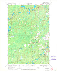
1970 Map of Lugerville
USGS Topo · Published 1972About this map
The Flambeau River and its South Fork dominate this Price County landscape, defining a region where water and timber drove development. Near the northern bend, Crowley Dam and an adjacent powerplant illustrate the mid-century industrial utility of these waterways. The presence of the Kimberly-Clark Wildlife Area and Flambeau River State Forest reflects a 1970s emphasis on conservation and managed wilderness. A legacy of earlier transport is visible in the Railroad Grade cutting through the center of the sheet, once serving the logging interests that operated near the Million Acre Swamp. Higher ground is marked by the Lugerville Lookout Tower, while local recreation is centered at Rocky Carry Park near the Rocky Carry Rapids. The map also details numerous named lakes, including Dankes Lake, Le Tourneau Lake, and Peters Lake, which fill the glacial depressions between the river forks.
Find a feature on this map
36 named features on this map. Tap any name to fly to it.
Don’t see what you’re looking for? This feature index may not catch every label — zoom into the map to look around manually.
Map Details
Editions of this 1970 Lugerville Map
2 editions found
Other maps of this area

1941 · Park Falls
USGS Topo · 1:48,000

1941 · Kennan
USGS Topo · 1:48,000

1941 · Kennedy
USGS Topo · 1:48,000

1941 · Phillips
USGS Topo · 1:48,000

1943 · Park Falls
USGS Topo · 1:48,000

1943 · Philliips
USGS Topo · 1:48,000

1945 · Kennedy
USGS Topo · 1:48,000

1945 · Kennan
USGS Topo · 1:48,000

1947 · Park Falls
USGS Topo · 1:48,000

1953 · Rice Lake
USGS Topo · 1:250,000