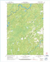
1970 Map of Lugerville
USGS Topo · Published 1992About this map
Lugerville sits at the eastern edge of a landscape defined by water and heavy timber, documented just as the 1970s began. The community is positioned near the South Fork Flambeau River, where Rocky Carry Rapids and Rocky Carry Park mark the river's descent. To the west, the massive Million Acre Swamp dominates the central terrain, bordered by the Kimberly-Clark Wildlife Area. This area serves as a significant intersection of conservation and industrial land management within the Flambeau River State Forest.
Find a feature on this map
34 named features on this map. Tap any name to fly to it.
Don’t see what you’re looking for? This feature index may not catch every label — zoom into the map to look around manually.
Map Details
Editions of this 1970 Lugerville Map
2 editions found
Other maps of this area

1941 · Park Falls
USGS Topo · 1:48,000

1941 · Kennan
USGS Topo · 1:48,000

1941 · Kennedy
USGS Topo · 1:48,000

1941 · Phillips
USGS Topo · 1:48,000

1943 · Park Falls
USGS Topo · 1:48,000

1943 · Philliips
USGS Topo · 1:48,000

1945 · Kennedy
USGS Topo · 1:48,000

1945 · Kennan
USGS Topo · 1:48,000

1947 · Park Falls
USGS Topo · 1:48,000

1953 · Rice Lake
USGS Topo · 1:250,000