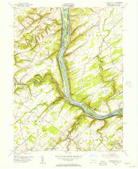
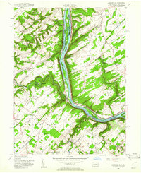
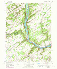
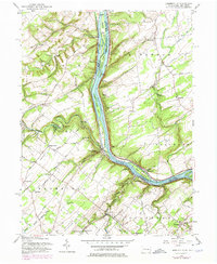
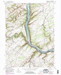
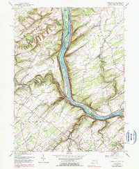
1955 Map of Lumberville
USGS Topo · Published 1956About this map
The Delaware River serves as the central artery for this mid-century look at the border between Bucks Co and Hunterdon Co. The landscape is defined by the parallel infrastructure of the Pennsylvania Railroad on the eastern bank and the Delaware Division Canal tracing the western shore. The river itself is punctuated by numerous named islands, including Treasure Island, Prahls Island, and Bulls Island.
Find a feature on this map
82 named features on this map. Tap any name to fly to it.
Don’t see what you’re looking for? This feature index may not catch every label — zoom into the map to look around manually.
Map Details
Editions of this 1955 Lumberville Map
6 editions found
Other maps of this area

1890 · Easton
USGS Topo · 1:62,500

1890 · High Bridge
USGS Topo · 1:62,500

1890 · Lambertville
USGS Topo · 1:62,500

1890 · Doylestown
USGS Topo · 1:62,500

1891 · Easton
USGS Topo · 1:62,500

1891 · Lambertville
USGS Topo · 1:62,500

1891 · Doylestown
USGS Topo · 1:62,500

1894 · Lambertville
USGS Topo · 1:62,500

1898 · High Bridge
USGS Topo · 1:62,500

1900 · Raritan
USGS Topo · 1:125,000
Featured Places
- Buckingham Township, PA
- Solebury Township, PA
- Bedminster Township, PA
- Tinicum Township, PA
- Kingwood Township, NJ