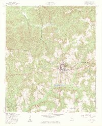
1955 Map of Lumpkin
USGS Topo · Published 1959About this map
Lumpkin serves as the central hub of this mid-century topographic study, showing the city's grid and development just before the mid-1950s. The surrounding Stewart County landscape is defined by a dense network of waterways, including Hodchodkee Creek which winds through the southern reaches and Frog Bottom Creek to the north. These drainage patterns, including the descriptive Wimberly Mill Branch, suggest a history of local water-powered industry and agricultural land use typical of southwest Georgia. To the north, the small settlement of Charles sits near the headwaters of Cotocher Creek, connected to the county seat by a straight corridor of travel that cuts through the intricate topography. The map detail reflects a transition period in rural infrastructure, capturing the layout of local roads and property orientations alongside long-established natural landmarks like Hightower Branch.
Find a feature on this map
7 named features on this map. Tap any name to fly to it.
Don’t see what you’re looking for? This feature index may not catch every label — zoom into the map to look around manually.
Map Details
Editions of this 1955 Lumpkin Map
3 editions found
Other maps of this area

1949 · Julia
USGS Topo · 1:24,000

1950 · Louvale
USGS Topo · 1:24,000

1950 · Lumpkin
USGS Topo · 1:24,000

1950 · Lumpkin SW
USGS Topo · 1:24,000

1950 · Lumpkin
USGS Topo · 1:62,500

1953 · Dothan
USGS Topo · 1:250,000

1954 · Dothan
USGS Topo · 1:250,000

1955 · Dothan
USGS Topo · 1:250,000

1955 · Lumpkin
USGS Topo · 1:24,000
1955 · Louvale
USGS Topo · 1:24,000