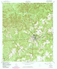
1955 Map of Lumpkin
USGS Topo · Published 1984About this map
Lumpkin serves as the regional hub for this Stewart County landscape, where the Seaboard Coast Line railroad cuts through the terrain east of the town center. The map reveals a deeply established community structure defined by its rural institutions, including Marks Ch, Ebenezer Ch, and Humbers Mission. Educational sites like Dowd Sch and Pleasant Valley Sch are positioned along the undulating topography, suggesting a network of small, localized school districts common in Georgia during the mid-20th century. The drainage patterns of Hodchodkee Creek and its many branches, such as Wimberly Mill Branch, dictate the placement of local industries and infrastructure. The presence of Ushers Millpond and Elders Pond near the town center highlights the importance of water management and milling history to the local economy before the late-century revisions.
Find a feature on this map
25 named features on this map. Tap any name to fly to it.
Don’t see what you’re looking for? This feature index may not catch every label — zoom into the map to look around manually.
Map Details
Editions of this 1955 Lumpkin Map
3 editions found
Other maps of this area

1949 · Julia
USGS Topo · 1:24,000

1950 · Louvale
USGS Topo · 1:24,000

1950 · Lumpkin
USGS Topo · 1:24,000

1950 · Lumpkin SW
USGS Topo · 1:24,000

1950 · Lumpkin
USGS Topo · 1:62,500

1953 · Dothan
USGS Topo · 1:250,000

1954 · Dothan
USGS Topo · 1:250,000

1955 · Dothan
USGS Topo · 1:250,000

1955 · Lumpkin
USGS Topo · 1:24,000
1955 · Louvale
USGS Topo · 1:24,000